Monday, July 27, 2015

Isle Royale National Park

You Can’t Get There From Here

A Packrafting Adventure Across Isle Royale National Park


The RANGER III cut through the gloomy fog and icy water of Lake Superior. We were halfway through a six-hour voyage from Houghton, Michigan to Isle Royale National Park and I was beginning to think that “lake” was a misnomer. But I suppose “Inland Sea of Freshwater Superior” just doesn’t have the same ring. I went below to check the campsite map one more time before filling out our backcountry permit application. I left the box for canoes and kayaks unmarked; we didn't have any.  I brought the permit to the Park Service Ranger down in the galley. She scrunched her nose and looked at it quizzically. Then she looked at me apologetically and pointed to our planned second night’s camp. “You know, without a canoe or kayak, you can’t get there from here.”

This trip was born a year earlier along the banks of the Kongakut River, deep inside the Arctic National Wildlife Refuge. I was fresh out of the service and headed to Alaska to cross the top items off my bucket list. Brothers Marty and Earl were enjoying retirement and came to witness the caribou migration. Earl was unaccompanied by his wife, so we set up our tents a little farther away from the others in “Bachelor’s Quarters.” We often stayed up late into the Arctic twilight, drinking river-chilled beer and bullshitting about travel we’d done and travel we’d like to do. Earl has the best stories and he’s also the first person I met that has a packraft. Lightweight and inflatable, packrafts were quickly becoming the next big thing in outdoor recreation, especially Alaska, by creating new opportunities for unique trips over land and water. We discussed the possibilities of such a craft in the Lower 48.

I bought a packraft at the end of that summer as a “souvenir” from Alaska. At Earl’s urging, Marty got one for Christmas. The three of us showed that rare ability to turn a great idea mentioned in passing into reality; meeting in Michigan over a year after our ANWR trip to explore the potential of the packrafts.


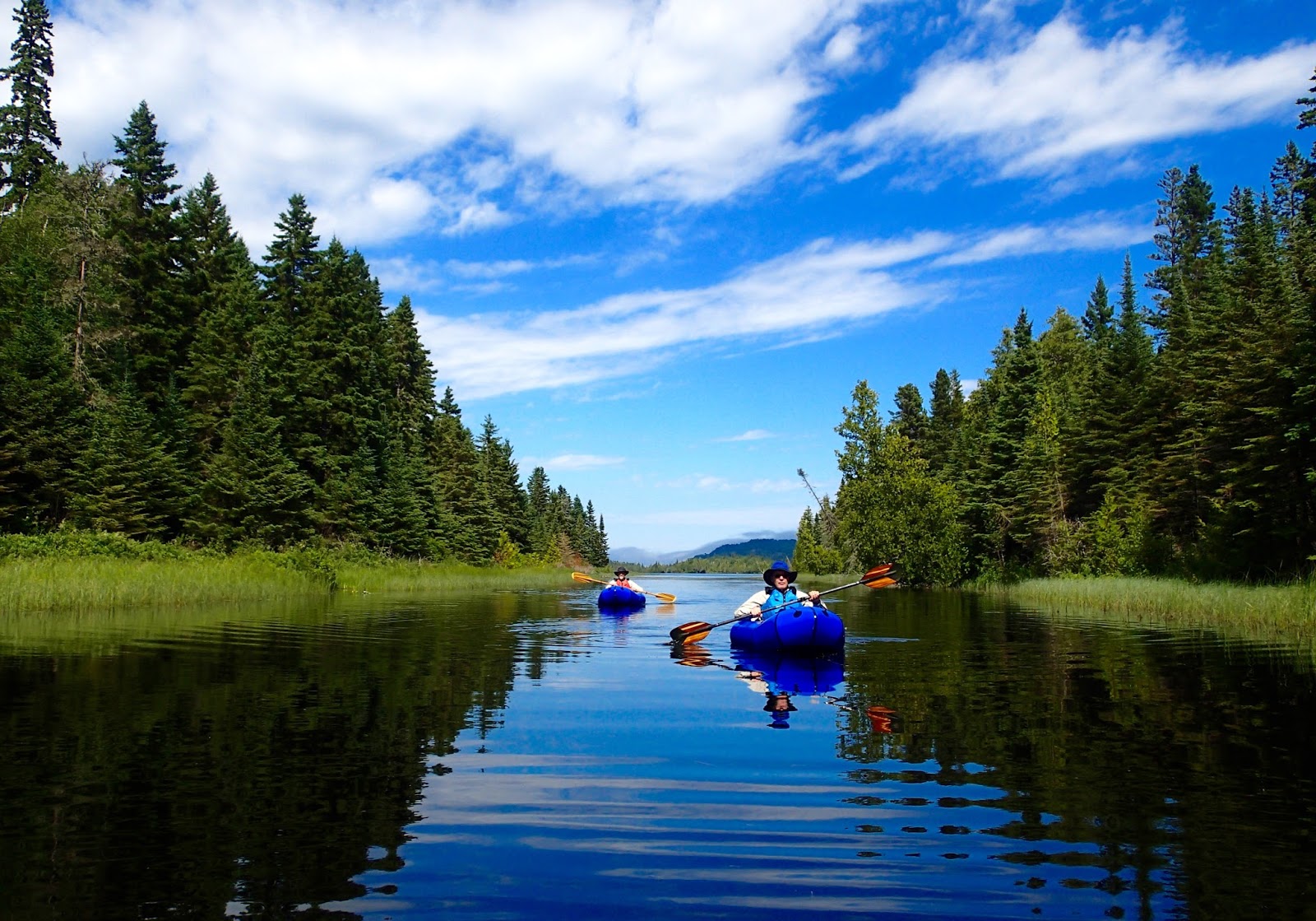
Isle Royale National Park is ideal for a packrafting expedition. The eastern end of the island stretches out into Lake Superior like the fingers on your hand. A left hand, palm up, to be more precise. Our plan was the head north from the ferry dock at Rock Harbor (on the “pinkie”) to Lane Cove (the little bay near the  “thumb”) crossing the fingers of land on foot and paddling rafts across the sheltered waters between. Then we’d hike south, looping across the “palm” to return to Rock Harbor. Hiking would save miles of paddling. Paddling would save miles of hiking.

We turned a few heads hiking off into the forest by Rock Harbor; the rolled up rafts likely mistaken for tents, making the paddle and lifejackets we carried appear superfluous. But unconventional has advantages: our first 30-minute paddle across a fjord cut out over 11 miles of roundabout hiking.  The subsequent portage, with only 5 extra pounds on our backs, was hours faster than boating around the long way.  Wilderness travel has never been so efficient.

Portaging made easy
Duncan Bay was our true “can’t get there from here” destination. A boat-in-only campsite, it was miles through thick forest and marsh from the nearest trail and backpacker.  And anyone in a more traditional watercraft would have to endure either a brutal mile-long portage or brave the full fury of Lake Superior out past the exposed eastern tip of the island. Needless to say, we had the place to ourselves.  We celebrated our good fortune with the sixer of beer I had packed in – a weighty and practically unfathomable luxury on a more traditional hiking trip.  But what’s a boating trip without beer? We sunk the brews to the cool depths of the lake and retrieved them at dinnertime with a string. 

At bedtime we availed ourselves of the provided “bug proof” shelters but quickly discovered an active insurgency of mosquitos had infiltrated and overwhelmed our position. We set up the tent bodies inside the shelter to create a second line of defense. Ensconced in the mesh, we were able to spend the remainder of the evening enjoying the haunting sound of loon calls across the water.


Isle Royale is home to both wolf and moose and the isolation of the island has lent itself to the longest running predator-prey study in history. However, the current state of the relationship is ominous – the wolves have suffered health problems due to inbreeding, with only three genetic mutants left. Without the wolves to keep them in check, the moose are in danger of eating themselves out of a home; massive starvation is predicted. Despite warning signs for a decade, the Park Service has just announced plans for an “impact study” that in proper bureaucratic fashion will take two years to complete. I think the wolves will be gone by then...

Undeterred by the dismal prospects, we set off on an evening paddle up a lily pad choked creek, lined with grass, alder, and balsam fir – a veritable moose buffet. And a moose buffet could easily turn into a wolf buffet, or so our thinking went. We saw loons fishing to feed their loonlings, a busy beaver, and a mohawked merganser with a dozen chicks in tow. But we turned around before we saw any wolf or moose due to the island’s other important predator-prey relationship, that between inflated PVC and sharp submerged sticks. The creek became increasingly “woody” and we couldn’t afford a major decline in the local packraft population.


Our dash across the top of Isle Royale to Lane Cove briefly left us open to a southerly wind off Lake Superior. We waited on shore for over an hour, hoping the whitecaps would die down and dreading the bushwacking prospects if they didn’t. We caught a small lull and went for it. The swell was still running and I was impressed with the seaworthiness of the little packrafts. Yet I got to thinking about our pre-trip planning and I was glad that Marty and Earl tempered my youthful ambition for a more aggressive paddling itinerary. It took me less than a half-mile on the big water to realize that Lake Superior is not to be trifled with.

After camping at Lane Cove we stowed our rafts for the longest overland portion of the trip, six miles crossing Isle Royale north to south to complete our loop.  We detoured up Mount Franklin to enjoy bird's-eye views of some of the waterways we had previously paddled. The Greenstone Ridge Trail was lightly travelled along its eastern end and overgrown with shoulder high berry bushes not yet ripe enough to eat. But Earl and Marty spotted early wild strawberries that packed an intense flavor despite their diminutive size. 


Organic strawberries

When we reached the island’s south shore, our original plan had been to hike the remaining three miles along the coast back to Rock Harbor. It was a clear day with vivid turquoise in the shallows. The gentle breeze was in a favorable direction, promising minimal effort on our part. We made a spur of the moment decision to enjoy a lazy paddle, made possible by the flexibility of packrafting. I inflated the boat and plopped in the water, lounging in the sun like the amphibian adventurer I had become.

Thursday, July 16, 2015

Da UP

Fueled with enough Tim Horton's caffeine to kill anyone under 120lbs and motivated to exfiltrate from enemy territory, I made the 500 mile drive from Ottawa to Michigan's Upper Peninsula in a single day.  I was welcomed in Sault Ste Marie like the prodigal American son that I am. Thanks to Dave the CBP guy, for being the first officer to not make me feel like a criminal for returning to my country of birth!

After a hearty breakfast scramble at Frank's Place, I stopped by the Soo Locks - one of the most heavily used lock systems in the world, with 18,000 annual transits. Lots of interesting Great Lakes maritime history in the visitor center and I was fortunate to witness the locking of upbound (meaning into Superior) "laker," the John G Munson.


I then made my way toward Pictured Rocks National Seashore. I thought I was being clever and taking a shortcut, but apparently "Yoopers" have a different idea of road quality than pretty much everyone else. The below photo was labeled and signed as a "major road" but the only thing "major" about it was the depth of the ruts and the endless miles of washboard.

It got much worse, but then I had to focus on not dying instead of photography
A little worse for the wear, I arrived in Munising, Michigan, in the heart of the Pictured Rocks sandstone formation. This hard-wearing rock is responsible for the creation of the lakeside cliffs and countless waterfalls. And it's laced with mineral deposits, particularly iron and copper, so that seeps and springs color the rock faces; hence the "pictured" rocks.

Miner's Rock, Pictured Rocks National Lakeshore
I hiked out to a number of interesting cliff formations, pretty waterfalls, and some beautiful beaches.

Grand Portal Point, Pictured Rocks National Lakeshore

I opted for the hike instead of the cruise
Chapel Creek Falls
Kayakers cruising by Chapel Rock
Lake Superior is aptly named. Such an impressive place. The sky was blue, the water was turquoise, kids were splashing in the waves, and gulls were wheeling and cackling in the sky. You'd forget for a minute you were over a thousand miles from the ocean; then you'd realize that you couldn't smell the salt on the freshening breeze.

Did I take a wrong turn in Canada and end up in Florida? Nope, this is Michigan! 
The mariners that ply the lakes don't often make that mistake though. The Great Lakes are as treacherous as any waters in the world. The strong icy winds from the Canadian Arctic to the northwest of Superior have turned its southeastern shore into a graveyard of ship skeletons. The frigid freshwater has done wonders to preserve many in remarkably good shape. I took a tour of the coast in a glass bottom boat to see some of the wrecks. Eat your heart out Robert Ballard!


All of the ships I saw were carrying iron or copper ore from the Upper Peninsula's numerous mines to the Midwestern manufacturing cities of Detroit, Chicago, etc. before they met their demise. I saw a lot of it spilt on the lakebed. But to see where it came from I toured the Quincy Mine, part of the Keewenaw Copper Mining National Heritage Complex. The Quincy Mine is home to a number of significant engineering feats, including the largest steam hoist, the largest concrete slab ever poured, and the deepest mine shaft at the time - over 9,000ft! We were only able to tour down to the 7th level of the mine, everything below that was flooded since the pumps stopped working. The 7th level was a cool 43*F but they said that before the mine was abandoned the lowest level was 100*F. Too close to liquid hot magma if you ask me!

*Insert inappropriate shaft joke here*
The Quincy Mine was productive from 1846 thru WWII, producing 1.4 billion (that's with a B) pounds of copper! 
All that mining makes for hungry miners. The mining experts from the 1800s were Cornish immigrants from the UK. They brought technical know-how for operations deep underground and in the kitchen; a lasting legacy in the UP of potpie type meals called "pasties." I had mine at Roy's in Houghton, served by Roy himself from a secret family recipe. 

Damn, I seem to be making this a habit. It was pretty tasty and I got halfway though before I realized I should take a photo
I don't have to go far for my next adventure, tomorrow the Isle Royale ferry leaves from Houghton, MI just a few blocks away from Roy's. 

Monday, July 13, 2015

Katahdin, Quebec, & Ottawa

I've long had my sights on Mt Katahdin. As the highest point in Maine and the northern end of the Appalachian Trail, it's a peak rich in hiking traditions. I'd decided I didn't want to thru hike the AT (I chose my two summer road trips instead) but Katahdin still held its allure.

Mt Katahdin as seen from South Turner Mountain. I ascended the left skyline. 
So on my way west from PEI I cut back across Maine and made the bumpy drive on roads beaten by logging trucks to Baxter State Park. In the 1920s, Maine's Governor Baxter had the foresight and generosity to use his own money to buy up a lot of the North Woods from the logging companies and then donated the land to the state. But he stipulated that conservation would take precedence over creature comforts: none of the roads in Baxter are paved, the trails are rugged, there is no running water, trashcans, or electricity.

One advantage of climbing Katahdin separate from an AT hike is your flexibility in route choices. I camped on the eastern side of the peak (the AT comes at it from the west) and chose the "Knife Edge" ridge trail. It was a fun, scrambly route with definite drop-offs and exposure, but a razor-blade it was not. There were a few admonitions from fellow campers to look out for certain tricky points on the trail, but I honestly didn't notice anything abnormally difficult. I think too many folks want paved boulevards to ease their way up tall mountains. It's supposed to be hard! Thanks Governor Baxter!

Katahdin's Knife Edge
The AT the easy way: Back in January, I hiked up Springer Mountain in Georgia. And then drove to Maine. 
I exited Baxter State Park and continued west into Canada for the second time on my trip (customs was easier this go around). But it certainly didn't feel like the same Canada I left a week before; in the province of Quebec everything is in French! Thankfully I took some French back in high school and remembered enough of it to get by with the occasional help from Google Translate. And apparently I stood out like a sore thumb and most folks immediately spoke English with me. However, I'm not sure I was legally parked at anytime during my stay in Quebec; the street signs were not bilingual.

With a commanding view of the St. Lawrence River, Quebec City controlled access into the interior of the continent and was strategically important to both French and British colonial ambitions. As a result the city is heavily fortified, with walls, gates, towers, and a citadel that stand to this day. Combined with the winding narrow one way streets, sidewalk cafes, colorful flower boxes, weathered limestone churches, impressive hotels, and French-everything you'll excuse anyone for thinking they are in Europe instead of North America.


Chateau Frontenac, the most famous hotel in Quebec 

Porte Kent, Quebec City
After a night in Quebec City I continued on to Montreal. Montreal is a much larger city, complete with skyscrapers and a metro, but down by the river you can still find Vieux-Montreal or the Old City. Again it had a distinctly European feel and ancient architecture, but it was far more crowded and less quaint than Quebec City. A major metropolis compared to a bustling village.

Basilica de Notre Dame, Montreal
I did enjoy a great night out on the town. While sampling my authentic French bistro dinner, I met a sailor from the Canadian Navy. We swapped sea stories (they had hosted a Coast Guard counter-narcotics team on his last cruise) and I was invited for a couple drinks up on a fabulous rooftop bar overlooking the Old City. A great view for the International Fireworks Festival hosted by Montreal. After the sailor left, I struck up a conversation with a local radio host and his date, both proud "Quebecois." We debated the pros and cons of Quebec independence from Canada long into the night. Apparently during the last referendum in '95 it was a close call, voted down by only a percent!

I said "au revoir" to Quebec and continued west to visit Canada's capital city of Ottawa. My first day in Ontario and I had to spend the night in jail!


A jail hotel! The coolest place ever! Old stone and wrought iron galore. My cell was only about 4x8. I think I would have volunteered for the death penalty instead of spending my life in there!

I posted bail in the morning and walked over to Parliament Hill to witness the Changing of the Guard, a ceremony in tribute to Canada's place in the British Commonwealth.  If Quebec City could have been North America's Paris, then Ottawa was London. A pipe and drum band leading a company of redcoats in bearskin shakos!

With Canada in our backyard who needs to travel to Europe?
I've got a long drive ahead along the north shore of Lake Huron, bound for the Upper Peninsula of Michigan at Sault Ste Marie.

Tuesday, July 7, 2015

Maritime Canada

After a long drive from Maine and a frustratingly thorough customs inspection (I guess it was the beard?), I arrived in Halifax, Nova Scotia. I unwittingly planned my arrival in Halifax for Canada Day; their version of 4th of July, but on the 1st of July. It was a fortunate accident and the city was full of fun and activities. I wandered around the festivities with some fellow travelers I met at the hostel.

Mounties un-mounted for a Canada Day parade
21 gun salute from the historic 78th Highlanders Regiment, protecting the Halifax Citadel since 1749
Happy Canada Day! Fireworks were cancelled due to fog. The Canadians apologized profusely.  
I had time to cruise around solo so I checked out the Halifax Maritime Museum. It was very well done and quite enlightening. I learned about the tragic harbor explosion of a WWI munitions ship in 1917. Until the atom bombs were dropped it was the largest detonation in history: a 1,000 pound chunk of the ship's anchor was found two miles from the waterfront! Downtown Halifax was devastated. I also learned quite a bit about the Titanic disaster - the initial rescue and salvage operations were based in Halifax.

A bannister from the Great Staircase onboard Titanic, recovered in the flotsam of the wreck.
A vivid and poignant reminder of the human tragedy that was the Titanic disaster. 
Departing Halifax I headed north to Cape Breton Island. Cape Breton is world famous for its scenic highlands and coastal drive. I camped and hiked for a few days to take it all in. Clearly owning to some geographical reminiscence of Scotland, many Scottish immigrants settled on Cape Breton and have formed an enclave of traditional Celtic culture, music, food, and single malt whiskey.

White Point, Cape Breton Island

The famous Skyline Trail of Cape Breton Highlands National Park
Cape Breton scenic driving
This is for you Adam Miller
75 minutes by ferry from Nova Scotia will get you to Prince Edward Island, a laid back rural farming and fishing community and what you would get if you threw Iowa, New England, hockey, and maple syrup into a blender. It was great to relax and read beside the beach and then hop into my truck and drive the backroads, blasting country music while enjoying the sun and pastoral scenery.


Great beachside camping. Thanks Canada! 
1 part New England, 1 part Iowa, add hockey and stir. Drizzle with maple syrup to serve. 
I don't normally photograph my food. A meal of renowned PEI mussels and potatoes.
Charlottetown on PEI has the distinction of being the "Birthplace of Confederation," where Canadian unification and eventually independence was first discussed by the political leaders of 1864, similar to what Philadelphia means to America. I toured some great museums, finding them both informative and a bit humorous. It seems that a significant causative factor in Canadian federation was the threat of the US Army heading north into British North America after our civil war as a payback of sorts for British aid of the Southern Confederacy. It cast Americans in a slightly sinister light, but I'll freely admit that I would have preferred to drive to Alaska without going through another country...

SAT refresher time. Independence Hall : United States :: Province House : Canada
Speaking of America, I'm off to Maine to check out Baxter State Park and take a shot at climbing Mt. Katadhin.

My accommodations on PEI - the Charlottetown Backpackers Inn. 

Thursday, July 2, 2015

New England

Road Trip 2015 started the same way things got going in 2014, by heading NORTH!

After a day of driving in atrocious weather, I made a quick stop in New London, CT for nostalgia's sake and ran into some old friends. And then it was out to Cape Cod, seemingly stopping at every whaling museum in Massachusetts. A fan of all things nautical, I enjoyed strolling through New Bedford, imagining myself in the opening chapters of Moby Dick.


Nantucket's whaling museum was the best in my opinion. New Bedford had a larger collection but those Quakers seem to have a knack for better organization and presentation. Beautiful scrimshaw and an impressive array of hideously efficient medieval-looking weaponry used to kill and chop up whales. The most memorable tale is one of the poor sap, often a small boy, that was lowered inside a hole in the whale's head to haul out the spermaceti oil with a bucket (cue nauseous puking sounds). The things we do for oil, but I guess some things never change...

Thar' she blows! Nantucket Whaling Museum
Scrimshaw, Nantucket Whaling Museum
At the end of Cape Cod is the beautifully restored Race Point Life Saving Station, a precursor to the US Coast Guard. 
The whole Kearns clan met up in Acadia National Park, a throwback vacation in tribute to one of my favorite trips from my high school days. Things are never the same, and Acadia was no exception. Cruise ships now anchor in Bar Harbor and the mountains are just a little smaller than the towering behemoths I remembered when I was 12. But it was a blast.

Dad and I were able to erase a longstanding asterisk on the summit of Champlain Mountain. We had wanted to hike it on our previous family trip but were weathered off. I'm glad we waited all these years later - the views of the Atlantic Coast were incredible, the Gulf of Maine full of colorful lobster buoys.

Steep trails! 
Champlain Mountain
And my sister, who wasn't quite up for epic long hikes back in the day, became my new stalwart adventure partner. We kayaked for loons, enjoyed some great views from the tops of the highest peaks in the park, and spent a morning rock climbing in one of the most impressive settings of my life - the sea cliffs of Otter Point!

Loon, 2 o'clock
Sargent Mountain
The Great Chimney, Otter Cliffs
Rapping down the Yellow Wall, Otter Cliffs
Yellow Wall, Otter Cliffs
We all headed our separate ways - Mom and Dad back to West Virginia. Chel off to Baltimore and her summer vacation from teaching. And I continued north to Nova Scotia, just in time for Canada Day!

Family hike up the Beehive.